We're loading the full news article for you. This includes the article content, images, author information, and related articles.
Kisumu County has partnered with the United Nations Development Programme (UNDP) to integrate drone technology into its disaster management framework, aiming to enhance real-time risk mapping and improve response to frequent hazards like floods and heatwaves.
Kisumu, Kenya – The County Government of Kisumu, in collaboration with the United Nations Development Programme (UNDP), has launched a drone-based risk mapping initiative to bolster its disaster management capabilities. This strategic partnership seeks to leverage advanced technology for real-time monitoring and data-driven decision-making in a county frequently affected by natural disasters.
The initiative, part of the broader “Strengthening Urban Resilience to Emerging Disaster and Climate Risks” project, is funded by the governments of Denmark and South Korea and is set to run until March 2026. It specifically targets cities with high disaster risk, including those vulnerable to floods, heatwaves, environmental degradation, and conflict.
Kisumu County is particularly susceptible to various hazards, including recurrent flooding, fire outbreaks, and the spread of diseases, exacerbated by rapid urban expansion and increasing informal settlements. The county's low-lying topography and black cotton soil hinder surface water runoff during heavy rains, leading to frequent inundation. In response, Kisumu has been actively working on disaster preparedness, with the County Government developing a Disaster Response Policy and having signed onto the Making Cities Resilient 2030 (MCR2030) global initiative.
The integration of drone technology aligns with Kisumu Governor Anyang’ Nyong’o’s vision of transforming Kisumu into a disaster-resilient county. The county already has in place the Kisumu County Disaster and Emergency Management Act, 2015, which provides a framework for disaster risk reduction, mitigation, preparedness, response, and recovery. This new initiative is expected to strengthen the implementation of these existing policies by providing enhanced tools for risk assessment and early warning.
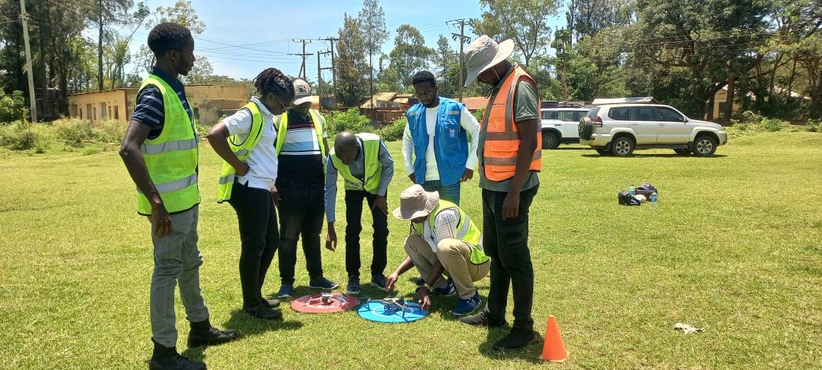
A key component of the project involves equipping the County's Emergency Operation Centre (EOC) with advanced tools, including flood-mapping drones and 3D modelling software. Furthermore, five technical officers from the county government have already received professional training and obtained Remote Pilot Licences (RPLs) from Drone Space, a Kenya Civil Aviation Authority (KCAA)-accredited institution. These officers will form Kisumu's first in-house drone mapping and risk analysis team, responsible for continuous data collection and geospatial analysis.
Salmon Orimba, the County Executive Committee Member for Disaster Risk Management, emphasised that this integration marks a turning point for Kisumu, providing real-time visibility of risk-prone areas and enabling faster, evidence-based responses. Raphael Mutitu, UNDP Disaster Risk Reduction and Resilience Specialist, noted that the collaboration reflects a commitment to utilising innovation and technology at the local level.
The drone technology will facilitate high-resolution mapping of critical infrastructure and vulnerable settlements, supporting risk-informed urban planning and sustainable development strategies. The initiative aims to provide contextualised and actionable risk information, improve governance systems, and strengthen capacities through the deployment of digital technology.
While the adoption of drone technology offers significant advantages, stakeholders urge clarity on timelines, costs, and safeguards. The effective implementation will depend on sustained funding, ongoing training, and robust data management protocols to ensure privacy and data security. The project aims to mitigate risks associated with natural disasters, ultimately safeguarding lives and protecting infrastructure.
Details regarding the long-term operational budget for the drone unit, specific maintenance plans for the equipment, and the mechanisms for public access to non-sensitive risk data remain to be fully elaborated. Ensuring community engagement and understanding of the new technology will also be crucial for its successful adoption.
The initiative, which commenced in October 2025, is scheduled to run until March 2026. The Emergency Operation Centre is expected to be fully equipped and operational by November 2025. The newly trained drone mapping and risk analysis team will be responsible for continuous data collection and geospatial analysis, embedding resilience efforts within the county’s technical systems.
Observers will be keen to monitor the effectiveness of the drone technology in predicting and responding to flood events, particularly during the upcoming rainy seasons. The integration of real-time data with existing emergency response mechanisms and the impact on reducing disaster-related losses will be key indicators of success. The development of the county's Disaster Response Policy will also be a critical area to watch.
Keep the conversation in one place—threads here stay linked to the story and in the forums.
Sign in to start a discussion
Start a conversation about this story and keep it linked here.
Other hot threads
E-sports and Gaming Community in Kenya
Active 9 months ago
The Role of Technology in Modern Agriculture (AgriTech)
Active 9 months ago
Popular Recreational Activities Across Counties
Active 9 months ago
Investing in Youth Sports Development Programs
Active 9 months ago