We're loading the full news article for you. This includes the article content, images, author information, and related articles.
A deadly combination of extreme rainfall, vulnerable geology, and decades of unchecked human activity has turned Elgeyo Marakwet's slopes into death traps. Streamline News investigates the policy failures and environmental warnings that were ignored for years, leading to a preventable catastrophe.
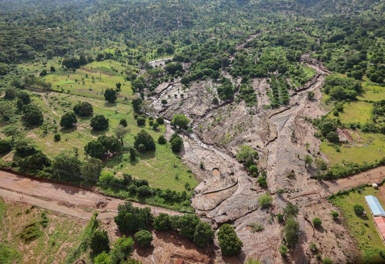
ITEN, Elgeyo Marakwet County – At least 34 people have been confirmed dead, with 17 still missing and over 6,000 households affected after devastating landslides swept through multiple villages in Elgeyo Marakwet County on Friday, November 1, 2025, and in subsequent days. The tragedy, triggered by relentless rainfall, has flattened homes, destroyed farms, and severed communication lines in communities perched precariously on the Elgeyo Escarpment. While the immediate trigger was intense weather, a Streamline News investigation reveals a deeper, more complex crisis rooted in a combination of unique geological conditions, shifting climate patterns, and critical failures in land management and governance.
According to a multi-agency government report updated on Tuesday, November 4, 2025, the villages of Chesongoch, Moror, and Kibendo are among the worst-hit. The government, through Interior Cabinet Secretary Kipchumba Murkomen, has deployed a multi-agency team including the Kenya Defence Forces (KDF) and the National Police Service to conduct search, rescue, and relief operations. However, rescue efforts have been severely hampered by the difficult terrain and persistent rainfall.
The Elgeyo Escarpment is one of the most dramatic features of the Great Rift Valley, a tectonically active zone. Geologists describe it as an inherently fragile environment. Its base is composed of ancient, hard metamorphic rock, but the upper layers consist of younger, looser volcanic soils. Professor Simon Onywere, a geologist who has studied the area, describes the escarpment as a “very steep and fragile feature” where settlement should never have been permitted. Research from the University of Nairobi confirms that the steep slopes created by the rifting process are naturally prone to landslides, especially when saturated with water. Studies have long warned that these slopes were “not inhabitable” and disaster-prone, yet communities have continued to live and farm there for decades.
The immediate catalyst for the disaster was an extended period of exceptionally heavy rainfall. According to Edward Muriuki, the Acting Director of the Kenya Meteorological Department (KMD), the ground was already saturated before the October-December rainy season began, following unusually heavy rains in the normally dry June-August period. This pre-saturation meant that any additional rainfall had nowhere to go, dramatically increasing surface runoff and the risk of mudslides. Muriuki and other scientists link the increasing frequency and intensity of such rainfall to climate change, which is causing more extreme weather events across Kenya and East Africa. The Elgeyo Marakwet County Climate Change Action Plan (2023-2027) explicitly warns that the escarpment is highly susceptible to erosion and flash floods due to its steep slopes and irregular, intense rainfall.
Experts and government officials agree that human activity has critically destabilized these already vulnerable slopes. Interior CS Kipchumba Murkomen directly attributed the scale of the disaster to “years of deforestation and poor farming methods.” The escarpment was once heavily forested as part of the Cherangany Forest system, a crucial water tower. Over decades, vast tracts of this forest have been cleared for settlement and agriculture. This deforestation has removed the tree roots that bind the soil together, leaving it exposed and unstable.
Furthermore, farming practices have exacerbated the danger. Many residents cultivate crops like maize on steep slopes without creating terraces or other soil-stabilizing structures. This allows rainwater to run off with immense force, stripping away topsoil and carving deep channels that weaken the slopes over time. The construction of homes has also played a role. To build on the hillsides, residents often carve out flat “benches,” creating small vertical walls that compromise the integrity of the slope. While some families settled on the high, dangerous slopes historically to escape conflict in the valleys, this has traded one risk for another.
This is not the first time Elgeyo Marakwet has suffered from deadly landslides; a similar event in 2020 also claimed dozens of lives. The recurrence of these tragedies highlights a stark gap between research, warnings, and policy implementation. Professor Onywere noted that studies conducted over a decade ago warned against settlement on the escarpment, but the recommendations were never enforced. Agencies like the National Environment Management Authority (NEMA) and the Water Resources Authority (WRA) are mandated to oversee such zones, but enforcement has been weak.
The government's response has focused on immediate rescue and relief, with President William Ruto assuring state support for hospital bills and funeral costs. However, long-term solutions are urgently needed. These include enforcing sustainable land-use planning, restricting settlement in high-risk zones, and investing in large-scale reforestation of the escarpment. The Kenya Red Cross and other agencies have also called for enhanced community training on early warning signs, such as ground cracks or water seepage, to facilitate timely evacuations. As the search for the missing continues, the Elgeyo Marakwet landslide serves as a devastating reminder of the price of ignoring scientific warnings and the urgent need for Kenya to build resilience in the face of a changing climate.
Keep the conversation in one place—threads here stay linked to the story and in the forums.
Sign in to start a discussion
Start a conversation about this story and keep it linked here.
Other hot threads
E-sports and Gaming Community in Kenya
Active 10 months ago
The Role of Technology in Modern Agriculture (AgriTech)
Active 10 months ago
Popular Recreational Activities Across Counties
Active 10 months ago
Investing in Youth Sports Development Programs
Active 10 months ago
Key figures and persons of interest featured in this article