We're loading the full news article for you. This includes the article content, images, author information, and related articles.
A groundbreaking US-based project has mapped America's carbon dioxide pollution with unprecedented detail. But as Washington proposes to scrap official emissions tracking, the data's release highlights a critical threat to global climate accountability
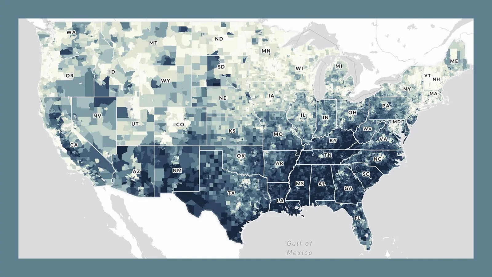
A team of American researchers has unveiled the most detailed map ever created of the United States' fossil fuel carbon dioxide (CO2) emissions, pinpointing pollution sources down to individual roads and factories. The data, released by the Vulcan Project, offers a stark visualisation of the carbon footprint of the world's second-largest emitter.
This new clarity on who pollutes comes at a precarious moment for global climate action. The U.S. Environmental Protection Agency (EPA) has proposed dismantling its Greenhouse Gas Reporting Program (GHGRP), a system that mandates major polluters to report their annual emissions. The move, intended to save businesses up to $2.4 billion (approx. KES 312 billion), threatens to create a critical data vacuum, undermining the very foundation of climate accountability that nations like Kenya rely on in international negotiations.
Led by Professor Kevin Gurney of Northern Arizona University, the Vulcan Project has spent two decades refining its methods to track CO2 emissions. The latest version provides an incredibly granular view of 2022 emissions, showing hotspots concentrated in densely populated areas, particularly along the US East Coast. "The U.S. taxpayers have a right to this data," Gurney noted, emphasizing its heightened importance as official government reporting faces existential threats.
While the Vulcan data provides a powerful independent tool, the potential loss of the official GHGRP, which covers an estimated 85-90% of the country's total greenhouse gas emissions, is a significant blow. This official data is crucial for verifying national commitments under global climate agreements.
For Kenyans, the emissions of a distant superpower are not an abstract concern. They are a direct driver of the climate shocks wreaking havoc on our communities. Kenya contributes a mere 0.18% of global emissions, yet it suffers disproportionately from climate-related disasters. The World Bank estimates that over 70% of natural disasters in Kenya, from devastating droughts in arid lands to severe floods in the Rift Valley, are linked to extreme climate events.
These are not future threats; they are our current reality:
The fight for transparent emissions data is therefore a fight for our future. Without verifiable data from major polluters like the U.S., holding them accountable for climate finance and loss-and-damage funds becomes nearly impossible. The U.S. has already shown resistance to proposals for climate levies on highly polluting activities, a measure supported by Kenya.
Independent initiatives like the Vulcan Project demonstrate that tracking emissions is scientifically possible with astounding accuracy. As lead author Kevin Gurney stated, such tools can help "confidently assure the public and governments that the intended reductions did occur." For nations on the front line of the climate crisis, the fight for this transparency is not just about data—it's about survival.
Keep the conversation in one place—threads here stay linked to the story and in the forums.
Sign in to start a discussion
Start a conversation about this story and keep it linked here.
Other hot threads
E-sports and Gaming Community in Kenya
Active 9 months ago
The Role of Technology in Modern Agriculture (AgriTech)
Active 9 months ago
Popular Recreational Activities Across Counties
Active 9 months ago
Investing in Youth Sports Development Programs
Active 9 months ago